-
Alfred Wegener (1880–1930), a German meteorologist and geophysicist observed that the continents of South America and Africa looked like they would fit together remarkably well. Similar fossils were found on continents separated by oceans, additional evidence that perhaps the landforms had once been joined. He hypothesized that all of the modern-day continents had previously been clumped together in a supercontinent he called Pan-gaea from ancient Greek, meaning “all lands” or “all the Earth”. Think Pan American Airlines.
This is consistent with the biblical account that “God said, Let the waters under the heaven be gathered together unto one place, and let the [singular] dry land appear: and it was so.” (Genesis 1:13)
Another source of evidence of the breakup of a single land mass into many are the deep scratches and sediments deposits left behind when a melting glacier containing rocks moves past a smooth rock. The Palaeozoic glaciation on Pangea left scratches on rocks, which are today found on several continents, far away from each other, but matching up like scattered jigsaw puzzle pieces.
Wegener had no idea what drove this movement, but mindful of his career at the least, supported the recently proposed long earth ages concept fundamental to the newly hatched idea of evolution. Based on an amateur examination of a tiny sample of Earth’s terrain in Scotland he assigned millions of years of “drift” by land masses for this phenomenon. Not scientific at all.
Geological discoveries over the last 200 years using scientific equipment such as seismometers and magnetometers resulting in the discovery of plate tectonics provides unequivocal evidence of catastrophic earth changes from volcanic eruptions, earthquakes, asteroid impacts and sudden climate change replaced the belief in slow drift with sudden shift. However, Uniformitarianism’s long earth ages paradigm remains (that’s a pun) the foundation of modern geology. Not scientific at all
The following is from a 3rd-5th grade level lesson plan: Rapid Changes to Earth’s Surface-earthquakes, landslides, volcanoes
-
Earth’s outer shell, or lithosphere, consists of roughly 20 large rigid plates on which the continents ride over a slippery layer of Earth’s crust. When these plates hit each other (think two cars on an icy road) their momentum at impact is converted to
1) bouncing apart at oceanic ridges, or
2) crumpling into heaps at subduction zones, or
3) slipping past one another along fault lines.
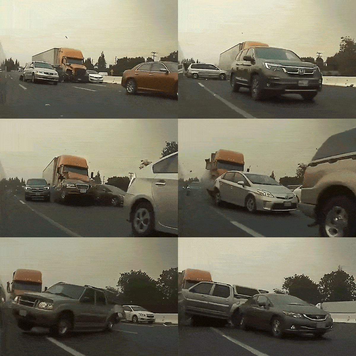
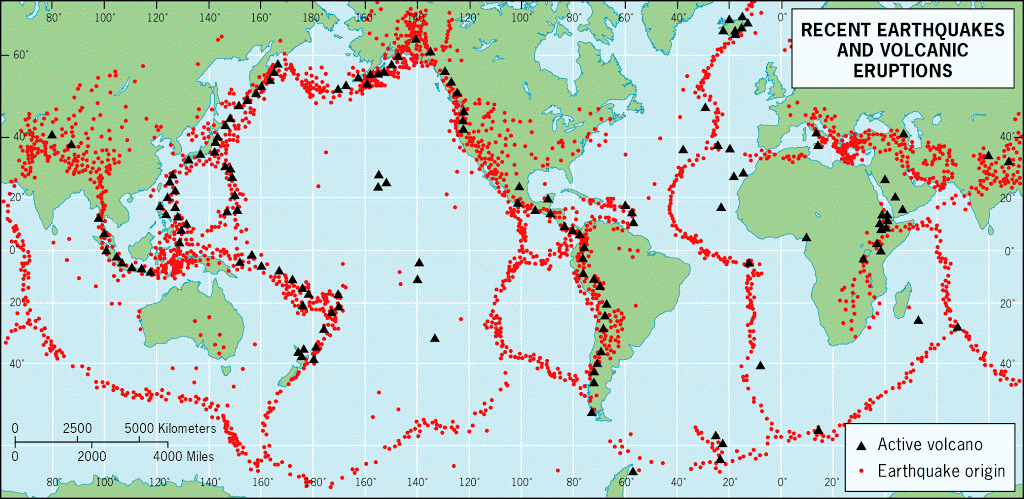
This releases potential energy as kinetic energy in the form of earthquakes, resulting in the same kind of crashing and sudden displacement with massive crumpling of the damaged material found in an expressway pile-up, only way more massive. And naturally, these damaged areas are found at the broken edges of what had once been one single landmass.
Extensive mountain-building events (orogenies) occurred where the continents collided with one another. The newly created high mountain ranges strongly influenced local and regional climates.
East-west atmospheric flow in the temperate and higher latitudes was disrupted by two high mountain chains—one in the tropics (Himalayas) oriented east-west and one running north-south (from Canada to Antarctica) —that diverted warm marine air into higher latitudes.
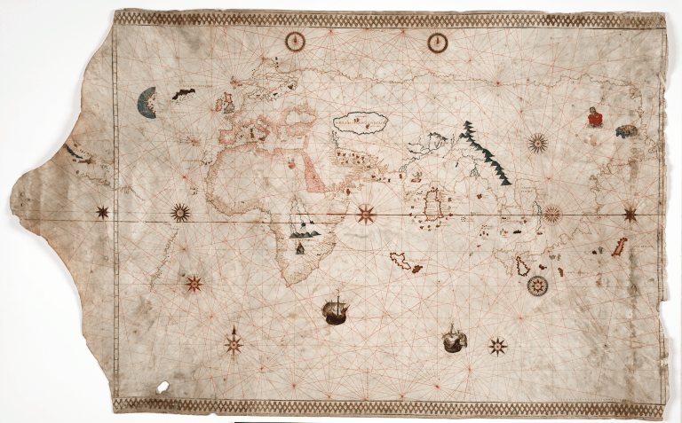
Evidence that these orogenies occurred within historic civilizations is found in numerous maps showing a world-wide climate not influenced by these tectonic events.
The Oronce Finé World Map displays features of Antarctica with ice-free rivers, valleys, and coastlines while also depicting the approximate location of what is the South Pole today.

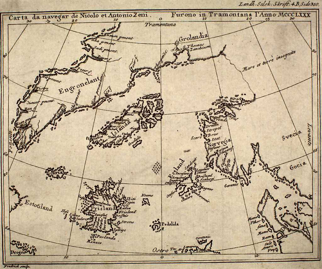
Zeno Map depicts Greenland free of glaciers, meaning that somehow, someone charted it prior to it being covered by ice.
King Jaime World Chart depicts parts of the Sahara Desert prior to current climate, showing fertile land, huge lakes, rivers and what appear to be ancient cities, including the possible location for the fabled Atlantis.
About 4300 to 4200 calendar years before present (B.P), during an ice age consistent with the aftermath of the biblical apocalyptic flood of Noah, the first historical empire was established by Sargon the Great between the Tigris and Euphrates Rivers. After only a hundred years of prosperity, however, the Akkadian empire collapsed. (Weiss et al., 1993; Postgate, 1992). Archaeological finds document widespread abandonment of the agricultural plains of northern Mesopotamia with dramatic influxes of refugees into southern Mesopotamia, triggering societal collapse (Weiss, 2000).
The geological stratigraphic level corresponding to the collapse at Tell Leilan in northeast Syria is overlain by a meter-thick accumulation of wind-blown fine sediments, evidence that the sudden demise of this complex civilization was due to a sudden and prolonged period of drought starting at 4025 ±150 years before present. Cullen et al. 2000,
The location is consistent with the above geological map of the clustering of tectonic activity, and the timing of this episode of tectonic activity corresponds to the biblical record of the earth breaking up during Peleg’s lifetime Genesis 11:10-19 with resulting sudden climate change causing widespread drought. At the same time the Akkadian Empire was experiencing severe drought there was widespread cooling in the North Atlantic (Bond et al., 1997; deMenocal et al., 2000).
As detailed in the post Civilization Rises, there was a rapid and enormous population growth in just a few hundred years after the flood, contributing to, if not causing, the climactic catastrophes. Drawing on the findings of almost 800 climate scientists, the IPCC synthesis report states that “Human-induced rapid changes to the climate system are now occurring in every region of the world, from rising sea levels to more extreme weather events to rapidly disappearing sea ice. The world must rapidly shift away from burning fossil fuels — the number one cause of the climate crisis.”
Today, between 3.3 billion and 3.6 billion people live in countries that are highly vulnerable to climate impacts, with global hotspots concentrated in the Arctic, Central and South America, Small Island Developing states, South Asia and much of sub-Saharan Africa. Across many countries in these regions, conflict, existing inequalities and development challenges (e.g., poverty and limited access to basic services) limit communities’ capacity to adapt or survive crises. For instance, from 2010 to 2020 mortality from storms, floods and droughts was 15 times higher in countries with high vulnerability to climate change than in those with very low vulnerability.
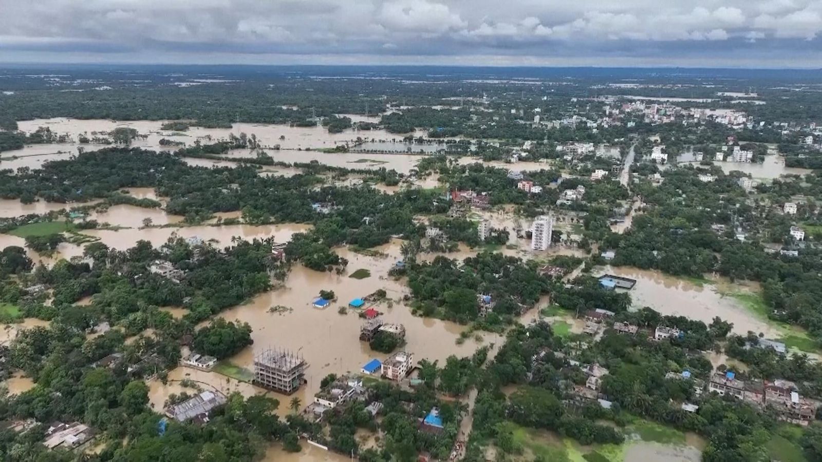
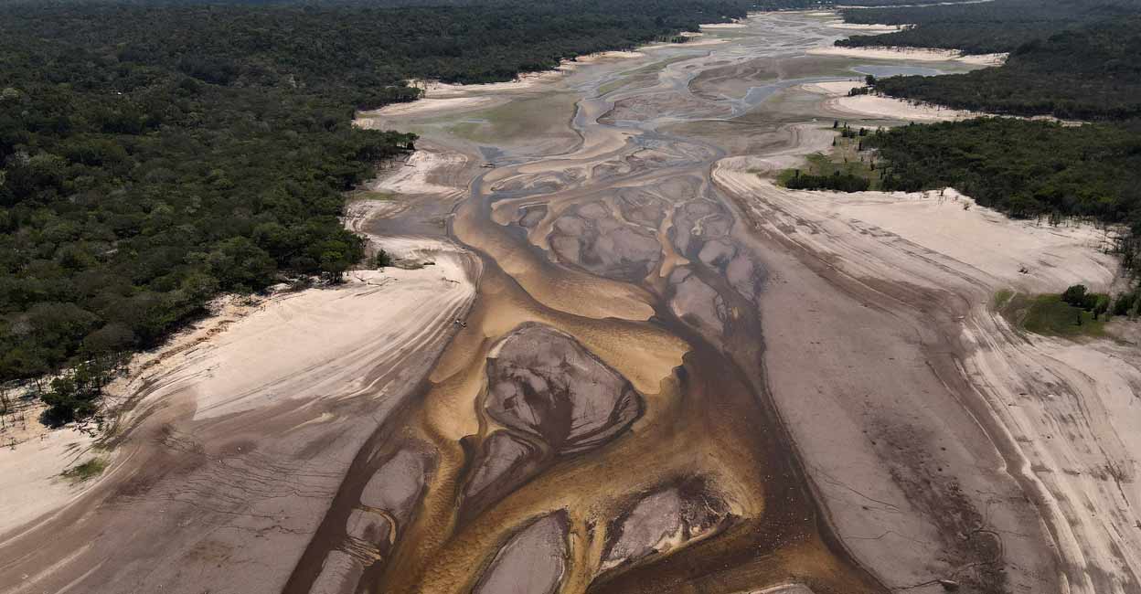
Meanwhile, severe drought is impacting other parts of the world including drying up the mighty Amazon River.
The IPCC’s AR6 makes clear that risks of inaction on climate are immense. Extinction of species happens not only rapidly but exponentially due to the interdependency of species.
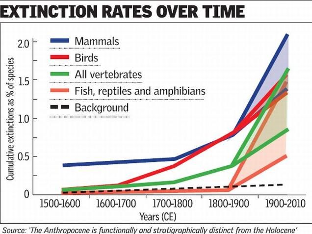
This, too, is documented in the geological record.
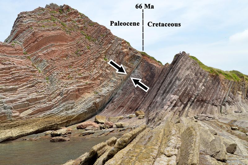
Like a bookmark, the K-Pg boundary is a thin but distinct layer of sediment found in rock formations all around the world. Dark in color, often appearing as a rusty red or dark grey, it is very fine-grained, feeling smooth to the touch, and distinctly different from the rocks above and below it by the presence of
- a metal called iridium that is rare on Earth’s surface but abundant in space in comets and asteroid,
- shocked quartz crystals indicating intense pressure, like what you’d get from a massive impact,
- tiny glass beads called tektites, formed when rock is melted and then quickly cooled, as happens during a meteor impact,
- soot and charcoal from burning wood.
This evidence has led many scientists to conclude that a large asteroid impact played a key role in the changes that occurred at the K-Pg boundary, linking cosmic events to Earth’s mass extinctions.
Rapid Evolution Changes Species In Real Time
Researchers who once assumed evolution required millennia are documenting species adaption in our lifetimes. Mosquitoes that colonized the London Underground in 1863 are now so different they can no longer mate with their above-ground relatives. Chinook salmon from Alaska to California needed just a human generation to become smaller and shorter-lived after an increase in commercial fishing in the 1920s.
-
A discovery, published in the New England Journal of Medicine, has raised concerns about the rapidly evolving nature of H5N1 / Bird Flu. After a prolonged battle with the disease a teenage finally recovered. However, genetic analysis of the virus that infected her revealed alarming mutations that could potentially enhance the virus’s ability to target human cells and cause severe illness. Experts are increasingly worried about the virus’s evolving potential and its implications for future outbreaks.
“Only time will tell whether researchers’ current arsenal of technologies is enough to untangle the complete story of human evolution.” That is just loaded with implications. Time is defined by deterioration, not increasing complexity.
Tragic consequences from ignoring reality do not just apply to climate change, signs of cancer, or world war. Anyone who accepts evolution rejects the Infinite Singularity who not only gives, but sustains life indefinitely. Doesn’t this decision deserve at least as much investigation as one would give before investing one’s life savings with an unknown telephone stocks solicitor?