-
-
“Then the LORD answered Job out of the whirlwind, and said, Who is this that darkeneth counsel by words without knowledge?…Where wast thou when I laid the foundations of the earth?
-
Although it is a huge continent the ATS forbids a resident human population or even any visitors without official clearance. It was the first arms control agreement established during the Cold War,
The obvious conclusion to be drawn from this Ice Curtain parallel to the USSR’s Iron Curtain blocking contact with the rest of the world is that access behind the Curtain grants a massive military advantage.
To understand this we need to track its military history, including Intelligence Services standard practices of hiding the truth with decoys.
Richard Evelyn Byrd was a member of the elite, one of the First Families of Virginia, which automatically granted him prestige, power, and political influence. We understand this very well in President Trump’s second term as President.
Byrd had been deployed by the U.S. Navy to Greenland to explore the Arctic region by the new technology of aeroplane. The Military-Industrial Complex business tycoons John D. Rockefeller and Edsel Ford as well as major media outlets such as the New York Times and CBS then funded his next flight to the North Pole in what became one of the most controversial flights in history.
This naturally raises doubts as to whether or not he actually accomplished his next reported feat of flying over the South Pole in 1929.
-
On both his flights to the North and South Pole Richard Byrd chose a Fokker Tri motor, Four fuel tanks held 110 gallons of fuel each for a total of 440 gal fuel. Fuel consumption was about 28 gal/hour 1) at cruising speed, 2) without extra fuel consumption for the 1,000-foot elevation of the Transantarctic Mountains. 3) or against the strongest and consistently blowing winds coming and going.
Check my math. At 440 gal / 28 gal/hr there was only enough fuel for 15.71 hours at cruising speed. Yet the flight is reported to have lasted 18.45 hours.
-
In 1933–35 a second Byrd expedition occupied Antarctica with the aim of claiming land around the Pole, during which Byrd spent five months alone in a hut, routinely enduring temperatures between −58° and −76° F (−50° and −60° C) and sometimes much lower before being rescued in a desperately sick condition.
-
In 1936. as whale oil became a key ingredient of Hitler’s four-year plan to boost his military and domestic economy to be ready for war by 1940. Germany staked a claim to territory in Antarctica “to use as a base for whaling” and photographing a large section of territory between hostile Norwegian and British zones.
At the express request of President Franklin D. Roosevelt Byrd took command of the U.S. Antarctic service and at the outset of WWII in 1939 led a third expedition to Antarctica until 1941, establishing three military bases.
-
How is it possible that the new map based on the latest high tech radar data show the exact same outline of the landmass as the crude 1947 map drawn from eyeball-squinting visualization of flat glaring white surface only?

-
The possibility that the Americans were following up on seized secret information about the Arctic regions from the Nazis is more credible than the story of Byrd’s aerial photography, given that the Nazi achievements in rocket science far surpassed anything being done by the rival Great Powers at that time. There was at least one expedition by the Nazi military for strategic advantage during WWII.
There is no question that the Americans and Russians launched the Space Race immediately after conquering the Nazis and seizing all their intellectual property.
This makes a connection between outer space and the polar regions that demands investigation.
Interestingly, Admiral Byrd’s 1947 South Pole expedition was abruptly closed down and he flew to the North Pole, stating “I’d like to see that land beyond the Pole. That area beyond the Pole is the center of the great unknown.”
- Informal, secret meetings during World War II between British and American code-breakers that took place before the US formally entered the war was formalized after the war in 1946. The Five Eyes (FVEY) intelligence alliance comprising Australia, Canada, New Zealand, the United Kingdom, and the United States was developed to monitor communications – first of the Soviet Union and Eastern Bloc, greatly expanding its surveillance capabilities during the “war on terror”, currently with much emphasis on monitoring the Internet.
When we view the location of the five countries on a map more or less correctly (this is hard to find) acknowledging the true curvature of the world, we can connect the dots between the Admiral Byrd’s North and South Poles expeditions resulting in the establishment of the Five Eyes intelligence gathering organization.
Australia to the south is one of the closest countries to the Arctic continent, clearly the Anglosphere competitor to Germany’s presence through Argentina, which is the closest, and has a station located on the very tip of the Antarctic Peninsula.
To the north, Greenland is approximately 1,243.68 miles (2,001.51 km) south of the North Pole and counted as part of the totality of “the Arctic” region. As of 2026 international controversy swirls around President Trump’s determination to take ownership of Greenland, maintaining that acquiring Greenland is crucial for U.S. national security.
The role of FVEY in the context of the evolution of wireless communication, and the presence of a shortcut between the Poles offers a better explanation for Trump’s obsession with acquiring Greenland beyond mere proximity of adversarial nations around the North Pole.
Satellites play a crucial role in modern military and defence operations, providing vital information and capabilities that enhance national security. Their ability to collect intelligence, conduct surveillance, and support communication systems makes them indispensable assets for armed forces globally.
The integration of satellite capabilities with ground operations allows for a level of precision that was once unattainable. In an era of rapid technological change, the ongoing development and deployment of satellite technology will likely shape the future of military operations significantly.
During the 1980’s satellite communication (SATCOM) was introduced, enabling long-range, real-time communication across global distances. Military forces could now communicate even in remote or hostile environments where traditional communication infrastructure did not exist. This expansion of connectivity was essential for operations in distant regions.
In the 1990s, the military embraced the growing potential of cellular networks and the internet. The integration of wireless networking with GPS technologies provided real-time positioning information for both ground and aerial operations.
In the early 2000s the military adopted advanced technologies like Wi-Fi, Bluetooth, and 3G/4G networks, which enabled faster and more reliable communication across various units. Secure wireless networks were developed, enhancing situational awareness and coordination during military operations.
Today, wireless communication in the military is undergoing a transformation with the advent of 5G technology. Additionally, military forces are exploring the use of artificial intelligence (AI) and machine learning (ML) to manage complex communications across vast areas.
Looking further into the future, 6G networks are expected to provide virtually instantaneous communication and a seamless connection for a variety of military applications.
The biblical model of the same “deep” / energy known to surround the earth also penetrating the earth would be a major military communications and weapons asset most certainly kept secret by the military-industrial complex.
- Informal, secret meetings during World War II between British and American code-breakers that took place before the US formally entered the war was formalized after the war in 1946. The Five Eyes (FVEY) intelligence alliance comprising Australia, Canada, New Zealand, the United Kingdom, and the United States was developed to monitor communications – first of the Soviet Union and Eastern Bloc, greatly expanding its surveillance capabilities during the “war on terror”, currently with much emphasis on monitoring the Internet.
I [ALONE!]…shut up the sea [image of conceptual chaos] with doors, when it brake forth [as a weapon of destruction]…
[In response] I [ALONE!]brake up [the sea itself turned against the adversaries] …That it might take hold of the ends of the earth, that the wicked might be shaken out of it…
It [the ends of the earth] is turned as clay to the seal [immobile]; and they [the wicked] stand as a garment [hung up, unmoving]. And from the wicked their light is withholden…
Hast thou entered into the springs [lowest sources] of the sea…the depth? Have the gates of death been opened unto thee? or hast thou seen the doors of the shadow of death?…
Hast thou entered into the treasures of the snow? or hast thou seen the treasures of the hail, Which I have reserved against the time of trouble, against the day of battle and war?…Who hath divided a watercourse for the overflowing of waters…The waters are hid as with a stone, and the face of the deep is frozen.“(Job 38:1-30)
The above description matches the interior of a toroidal earth, entered via the South Pole at Antarctica.
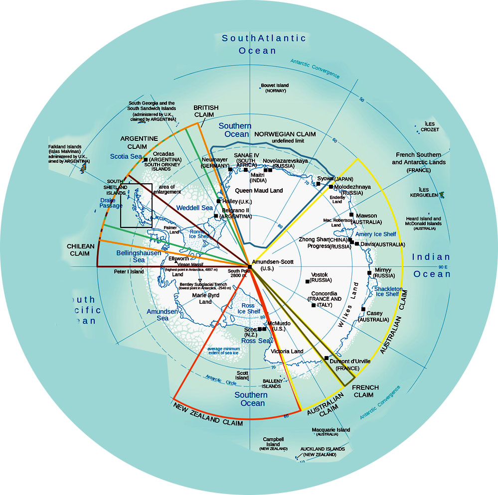
The Antarctic has been determined to be so critical to world stability that it is regulated by international relations rather than a national constitution through the Antarctic Treaty System (ATS). As of 2024, the treaty has 58 parties. The land is divided, not by geographical boundaries like mountains and river and mineral deposits, but in a most interesting pattern of geometric wedges of a circle so every party has access to the South Pole at the center.
Magnetic compasses were useless so near either of the poles, so the explorers were forced to rely on sun compasses and Byrd’s skill as a navigator to locate the Poles.
Locate the Poles? How? There were no maps or geological triangulation points.
So, no. Basic fifth grade math calculations indicate that Byrd did not make it to the South Pole and back again.
After just two months of work the expedition was precipitously withdrawn back to the United States. The likely reason would be that the expedition had accomplished its goal of claiming the South Pole as belonging to the U.S.

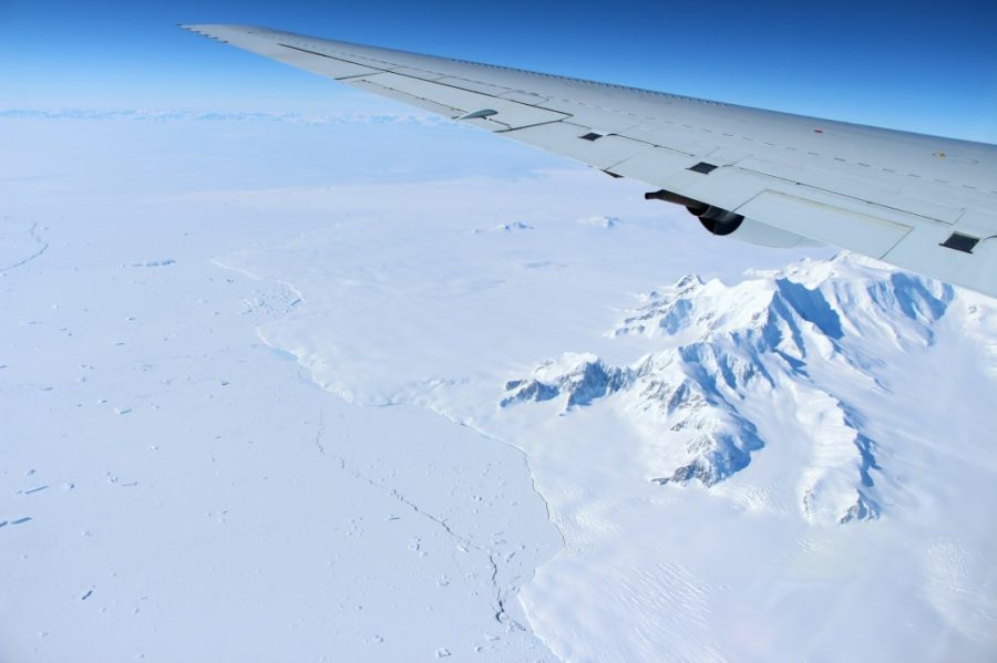
After World War II Byrd was placed in charge of the U.S. Navy’s Operation High Jump, the largest and most ambitious exploration of Antarctica yet attempted, Operation High Jump’s ship- and land-based aircraft mapped over 1.5 million square miles of territory and more than 70,000 photos had been taken.
Unfortunately, a large percentage of the photographs were rendered useless due to a lack of adequate ground control points. Remember, Antarctica is essentially flat white.
Fortunately, this deficiency was rectified the following year by a much smaller expedition, Operation Windmill composed of the icebreakers Edisto and Burton Island, which succeeded in obtaining most of the needed ground control points.
Fortunately, but realistically? From ships around the periphery? And only about one per cent of Antarctica is visible above the ice sheet covering it, which in some places is 12,000 feet thick.
Operation High Jump’s ship- and land-based aircraft only mapped and photographed 10% of Antarctica’s reported total land mass of 5,500,000 square miles.
But amazingly!, in 2010 the contours and size of Antarctica as determined by Admiral Byrd’s low resolution photographic equipment were confirmed by satellite imaging!
Researchers from NASA’s Goddard Space Flight Center in Greenbelt, Md., led a team that used high-resolution satellite images, along with newly developed computer software, to trace the most accurate Antarctic grounding line ever compiled. The point where ice separates from land is called the “grounding line…”
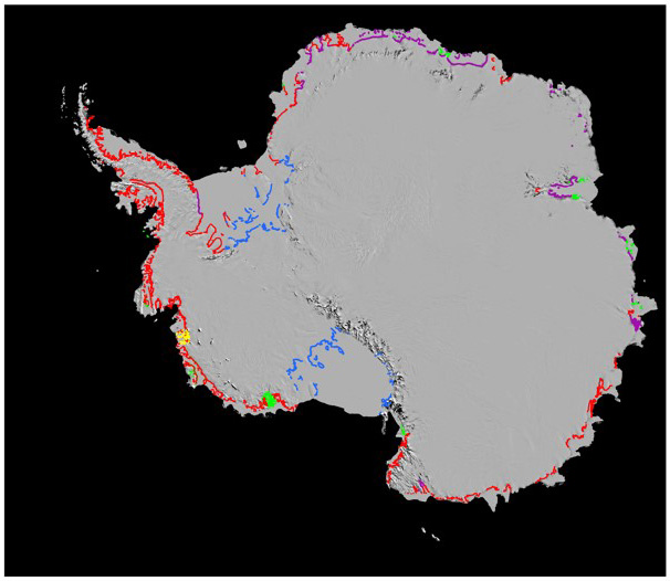
The red dots are the data points for the new map, overlaying the previous map compiled in 1946-47.