- below the lands of Elves / righteous angels in heaven and the gods / fallen angels in the surrounding sea / chaos above the firmament
- and above the land of the Giants / demi-god] and the Dead.
The Bifrost Bridge, extended from Middle-earth to Asgard across the 1st heaven (atmosphere surrounding earth, the 2nd heaven (spiritual chaos of “outer space”), to the 3rd heaven, dwelling place of God and his righteous sons.
Geard / guard meaning ‘enclosure’ is what the Greeks called the οικουμένη (oikoumenē) or “the abiding place of men”, what the Romans called the “Medi-terranean”, which remains the center of attention for both earth history and maps, and what the Hebrews called Eden / delight, the whole earth, not just the garden, since “the LORD God planted a garden eastward in Eden.” (Genesis 2:8)
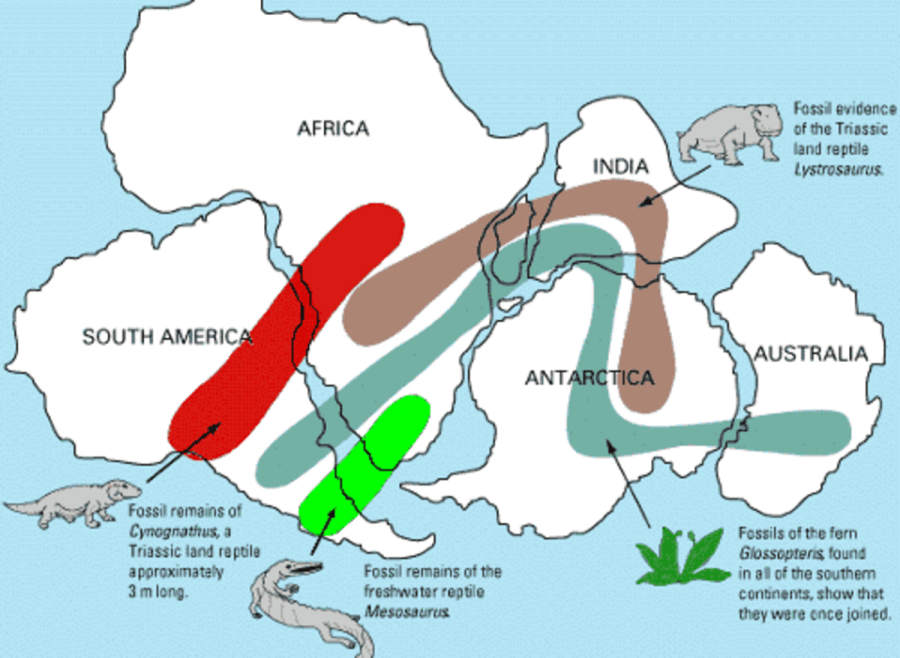
In 1912 the German geologist Alfred Wegener conceptualized Pan-gea/All-earth by recognizing that the recently unearthed fossil evidence connected the continents like puzzle pieces, imaginatively conceiving of continental drift as the mechanism for the breakup in order to support the unsubstantiated and actually disproven long earth ages theory for the evolutionary paradigm.

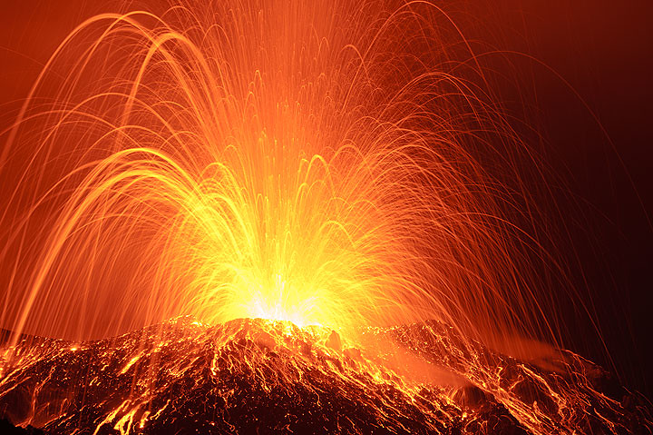
Santorini, Greece is a microcosm of the spasmodic breakup of the whole earth,with ongoing activity still occurring.

In January 2025 Santorini and neighboring islands experienced over 28,000 earthquakes, several over a magnitude of 5.0 for over a month. “These events serve as a long-term warning of potential future activity.”
These current events also serve as scientific proof of biblical records of past activity, which biased scientists refuse to admit.
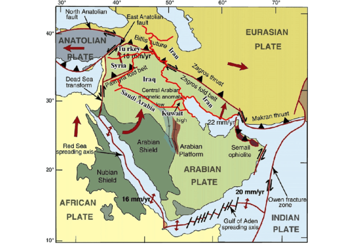
One notable area of continental breakup is found at The Great Rift Valley, which begins between the Lebanon [Mountains] and Anti-Lebanon [Mountains], runs along the Jordan Valley, the Dead Sea, the Arabah, the Aqaba gulf, the Red Sea, and continues through the continent of Africa as far as Zimbabwe.
“Prehistoric man witnessed the latest phases of widespread tectonic movements which convulsed East Africa and provoked great subsidences [lowerings of the land].”
Hello! Some of those “prehistoric” men are recorded in the biblical history book with peerless biographies maintained unbroken through generations over six thousand years.
Note – for the purpose of more easily following a trail of connected events I round off the exact numerical values provided in the database.
Starting ~4000 BC at creation:
“The LORD God planted a garden eastward in Eden / Medi-terra, and a river went out of Eden to water the garden; and from thence it was parted, and became into four heads.
- Pison, which compasseth the whole land of Havilah / Arabian Peninsula. In keeping with this study of geographical changes, this river no longer exists, but its ancient riverbed has been spotted by satallite studies.
- Gihon that compasseth the whole land of Ethiopia / Nile.
- Hiddekel which goeth toward the east of Assyria / Tigris.
- And the fourth river is Euphrates.” (Genesis 2:8-14)
Peleg’s “days” ends about 300 years after the flood when Abram is about 50 years old, through whose travels we can continue to track biblical records of ongoing geological changes.
“And Terah took Abram his son, and Lot the son of Haran his [deceased] son’s son…and they went forth with them from Ur of the Chaldees…and they came unto Haran [obviously named by him in memory of his deceased son], and dwelt there.” (Genesis 11:27-31)
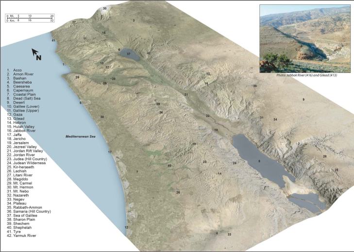
The following map provides visual context for this biblical journey.

WRONG! This shows the course of the Euphrates River as it is known to exist today, with its headwaters in mountainous Turkey rather than the Mediterranean.

The biblical account written 700 years after the flood when Moses recorded these rivers as they were known at that time to his immediate audience of international Hebrew refugees in their exodus from the Egyptian empire describes these four rivers as originating in Eden / Mediterra and flowing east.
It is known at this time that the Middle East has been wracked with highly destructive tectonic activity since time immemorable.
Geologists unintentionally validate the Genesis account by the admission that
- the same tectonic events that caused the breakup of Pangea into continental shift
- were responsible for “modifying notably the courses of the rivers…along the entire length of the Great African Rift.”

For example, the Red Sea, which stretches for several hundred kilometers without a single affluent / inlet river from its African border, nonetheless contains fish and fauna belonging to the Ethiopian zoogeographical region. The scientific explanation is that in the past there was a huge river system consisting of multiple rivers in the Jordan River Valley, and, without crediting Moses’ account, the Red Sea’s Ethiopian flora and fauna are remnants of “Gihon that compasseth the whole land of Ethiopia”, as well as the Nile riverbed, whose waters reversed direction due to geological upheaval.
The Jordan River also reversed its direction, according to an inscription of Thutmose I which reads: “Frontier northern [of Egypt], as far as that inverted water.”
The changes that this crust and tectonic movement created in South America eventually reversed the flow of many of the rivers in an easterly direction towards the Atlantic as opposed to the Pacific or Caribbean.
The deepest place in the Rift on land is not in Africa despite the looks of it as shown in the photo below,
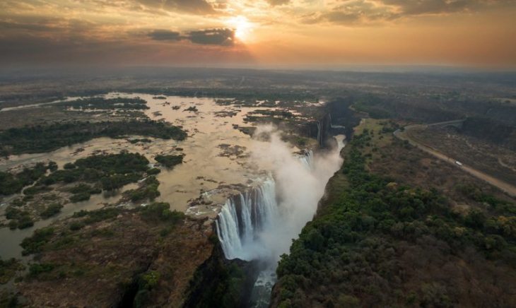
but the Jordan River Valley, accounting for the tremendous separation of the four rivers from their original joint headwater.
The Dead Sea sits in the largest and deepest basin in the world. Accordingly an international team of scientists drilled beneath its seabed to extract what they expected to be a continuously dry record of lengthy periods of climate change and earthquake history. However, instead they found wildly varying layers of dry and wet periods and even a tiny fragment of wood, not petrified, along with gravel similar to that found today on the nearby shores of the Sinai Peninsula, indicating a geologically recent history.
What caught their interest, then, was a temperature of 104 degrees inside pipes about 1,300 feet down, evidence of a current subduction zone consistent with a geologically recent Great Rift in the area.

Of the six types of volcanic activity, subduction zones produce Stromboli eruptions in contrast to lava flows of, essentially, melted glass, fitting the description of the event at Sodom and Gomorrah witnessed by Abram and included by Moses in his history of the Hebrew people.
“The LORD rained upon Sodom and upon Gomorrah brimstone and fire from the LORD out of heaven; And he overthrew those cities, and all the plain, and all the inhabitants of the cities, and that which grew upon the ground…And Abraham gat up early in the morning to the place where he stood before the LORD: And he looked toward Sodom and Gomorrah, and toward all the land of the plain, and beheld, and, lo, the smoke of the country went up as the smoke of a furnace.” (Genesis 19:23-28)
Another source of tremendous breakage of earth is the aftermath of an asteroid impacts, which can hit with such force that they have similar effects to a volcano, instantly transforming rock into molten material shooting upwards into the atmosphere, then raining down, causing more widespread damage than from a volcano with wildfires carried by superheated winds.
For example, the Chicxulub asteroid, known by its crater which is nearly 10 kilometers (6.2 miles) across, hit the Earth near what is now the Yucatan Peninsula. With the effect of a cannonball into a swimming pool, a 1.5 km high tsunami immediately followed the impact, with subsequent tsunamis 50 to 150 meters high created by ensuing massive earthquakes between 9-11 in magnitude at the impact site, and radiating out worldwide as the geological shockwave triggered earthquakes and volcanic activity around the world, with wildfires raging out of control in 70% of the world’s forests. The dust and gases ejected into the atmosphere would have led to a nuclear winter-like effect, with a rapid decrease in global temperatures. Vaporized carbonate rock entering the atmosphere, in addition to the global wildfires, would shift the climate to global warming due to the greenhouse effect.
Logic demands that scientific evidence of world-wide geological aftershocks proving the unseen causative agents also prove the biblical account of their causative agent the world-wide flood.