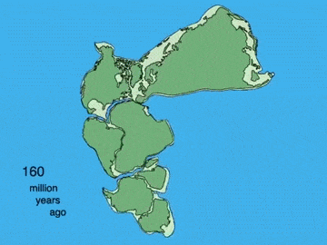
The originally single mass of earth called Pangea breaks up shortly after the flood. This is scientifically expected from the aftershocks of the volcanic and cosmic beating that precipitated the flood waters on the earth.
From Genesis 11:11-19:
-
-
- Noah’s grandson Arphaxad born two years after the flood
- Salah born when his father was 35 years old
- Eber born when his father was 30 years old
- Peleg born when his father was 34 years old, i.e. 100 years after the Flood, and lived for another 239 years, i.e. died 339 years after the Flood.
- Eber born when his father was 30 years old
- Salah born when his father was 35 years old
- Noah’s grandson Arphaxad born two years after the flood
-
At some point during Peleg’s lifetime he was associated in some way with what would have been the deadliest natural disaster since the Flood. Think the 2004 tsunami in Indonesia. Since, unlike Nimrod, he was not personally responsible for the notoriety, it was most likely at birth, like Jacob and Esau, that he was memorialized by the name / noun “Peleg / divided” “for in his days / beginning at birth was the earth [verb] divided” (Genesis 11:10-19). (Like Peleg, from the age of ten my forever memorialized with breakage was in my case the red mixing bowl.)
“In his days”, from about 100 years post-Flood up to about another 100-200 years, the earth underwent shattering aftershocks. This is consistent with geological and astronomical findings.
Through the International Ocean Discovery Project, U.S. National Science Foundation-funded scientists have discovered an immense amount of information about the effects on earth in the aftermath following the immediate damage from an asteroid’s impact.
Whether or not this particular asteroid struck during the Flood or Creation isn’t important. As per the purpose of the research, any time asteroids hit, the same resulting pattern of destruction of earth happens, more or less, depending on the size of the asteroid(s).
Map of known asteroid craters.

The Chicxulub crater was formed when an asteroid nearly 10 kilometers (6.2 miles) across hit the Earth near what is now the Yucatan Peninsula.
The impact was accompanied by a massive plume of molten material shooting up into the atmosphere, then raining down, causing wildfires in 70% of the world’s forests carried by superheated winds. A 1.5 km high tsunami immediately followed the impact, with subsequent tsunamis 50 to 150 meters high created by ensuing massive earthquakes not only at the impact site (of a magnitude between 9 and 11), as the geological shockwave from the asteroid triggered earthquakes and volcanic activity around the world.
The dust and gases ejected into the atmosphere would have led to a nuclear winter-like effect, with a rapid decrease in global temperatures. Vaporized carbonate rock entering the atmosphere, in addition to the global wildfires, would shift the climate to global warming due to the greenhouse effect.
Notice how, even after Pangea broke up, the “Medi-terranean”, which translates as “Middle-Earth”, remains the center of attention for both earth history and maps.
The term “Middle-earth” in the Hobbits mythos was not invented by J.R.R. Tolkien. Rather, it comes from…the Old English word middangeard (geard not meaning ‘Earth’, but rather ‘enclosure’ or ‘place’…It is Germanic for what the Greeks called the οικουμένη (oikoumenē) or “the abiding place of men”, the physical world as opposed to the unseen worlds…
In ancient Germanic and mythology, the universe was believed to consist of…interconnected physical worlds.
- The world of Men, the Middle-earth, lay in the centre of this universe. This is transparently the equivalent of the single land mass the Greeks called Pan-gea.
- The lands of Elves, [righteous angels] gods [fallen angels], and Giants [demi-gods] lay across an encircling sea [consistent with the biblical sea above the firmament]
- The land of the Dead lay beneath the Middle-earth [consistent with the biblical account]
- A rainbow bridge, Bifrost Bridge, extended from Middle-earth to Asgard across the sea. [The third heaven, where the biblical God dwells].
- An outer sea encircled the seven other worlds (Vanaheim, Asgard, Alfheim, Svartalfheim, Muspellheim, Niflheim, and Jotunheim). [Consistent with the multiverse concept of contemporary physics, and multiple iterations of this world in the Bible.]
The biblical equivalent of the Germanic middangeard / middle enclosure is Eden.
“And the LORD God planted a garden eastward in Eden [which was therefore a much bigger area than just the garden]. And a river went out of [the western area of the whole territory of] Eden [going east] to water the garden and from thence [once out of the garden in eastern Eden] it was parted, and became into four head[water]s:
- The name of the first is Pison: that is it which compasseth the whole land of Havilah, where there is gold; And the gold of that land is good: there is bdellium and the onyx stone.
- And the name of the second river is Gihon: the same is it that compasseth the whole land of Ethiopia.
- And the name of the third river is Hiddekel: that is it which goeth toward the east of Assyria.
- And the fourth river is Euphrates.” (Genesis 2:8-14)
Call me crazy, but I’m assuming that the geographical reference is included because it was meaningful at least to the readers of this account compiled by Moses. These would be the international horde of refugees (see relevant post for details) Moses had just led out of Egypt, which is dated about 1,000 years after the flood of Noah.
Therefore, the premise for locating the Garden of Eden is that, even after the flood, the inhabitants of this region could still recognize the named geological features.
Today we can’t find one river parting into four separate rivers within the biblical lands. This would be due to geographical features being altered by massive hydraulic and tectonic forces – not during the flood – but occurring as aftershocks even after Moses recorded known landmarks and names for these rivers 1,000 years after the flood.
This is validated by geological science which has located still-ongoing tectonic activity at these sites thousands of years later in our time.
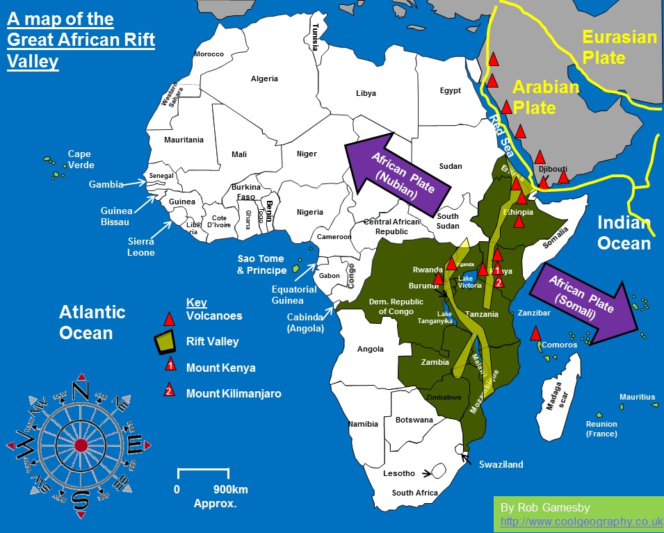
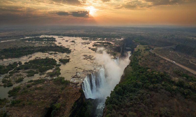
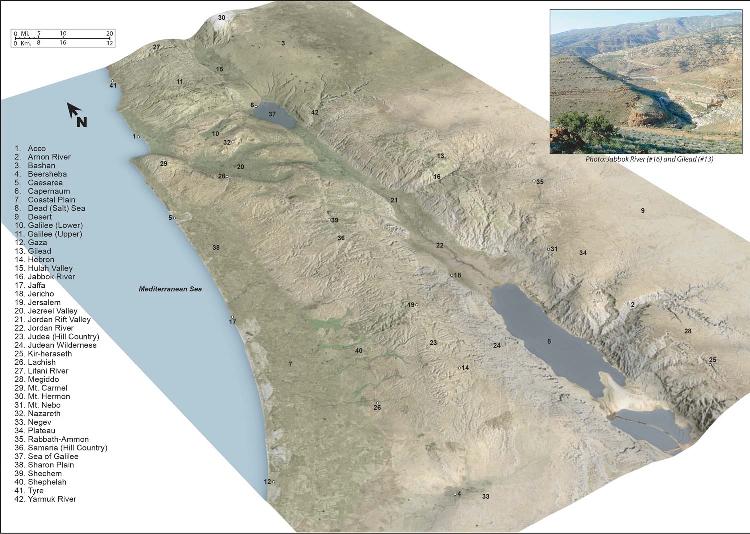
The Great Rift, which begins in Syria between the Lebanon [Mountains] and Anti-Lebanon [Mountains], runs along the Jordan Valley, the Dead Sea, the Arabah, the Aqaba gulf, the Red Sea, and continues through the continent of Africa as far as Zimbabwe, is generally regarded as the product of a grandiose revolution in the shell of the Earth…
Prehistoric man witnessed the latest phases of widespread tectonic movements which convulsed East Africa and provoked great subsidences [lowering of the land] (of as much as 1500 feet or more)…modifying notably the courses of the rivers [emphasis added]…along the entire length of the Rift.
Some of those “prehistoric men” are recorded in the biblical history book – invalidating the Evolution-driven dating of this event.
“The sun was risen upon the earth when Lot entered into Zoar. Then the Lord rained upon Sodom and upon Gomorrah brimstone and fire from the Lord out of heaven; And he overthrew those cities, and all the plain, and all the inhabitants of the cities, and that which grew upon the ground…And Abraham gat up early in the morning to the place where he stood before the Lord: And he looked toward Sodom and Gomorrah, and toward all the land of the plain, and beheld, and, lo, the smoke of the country went up as the smoke of a furnace.” (Genesis 19:23-28)
The deepest place in the Rift on land is [not in Africa despite the looks of it as shown in the photo above, but] the valley of the Jordan and the Dead Sea. It appears that the catastrophe which originated the Dead Sea caused also the origin of the Great Rift.
An international team of scientists has been drilling beneath the [Dead] seabed to extract a record of climate change and earthquake history. Since the Dead Sea sits in the largest and deepest basin in the world the scientists assumed that the sediment that had accumulated there had always been under water, the better preserved for having never been exposed to the atmosphere. but the wildly varying layers of salt and mud represented dry periods and wet ones, respectively. A tiny fragment of wood, which Mr. Lazar said he was guarding like gold, was found, with gravel similar to that found today on the shores of the Sinai Peninsula
There was a momentary hint of another mystery…a temperature of 104 degrees inside pipes about 1,300 feet down, a finding much higher than expected…
The reading gave rise to thoughts of volcanic activity, right in the area where Sodom and Gomorrah…described in Genesis as having been destroyed by God with fire and brimstone.
Of the six types of volcanic activity, a Stromboli eruption best fits the description with only small chunks of lava, collectively called tephra, of spatter, scoria, lava bombs, ash; and small lava flows. This contrasts with massive lava flows of, essentially, melted glass, as occurred at Mount St. Helens which obliterated everything in its path, or explosions of superheated gases and ash as occurred at Vesuvius. One of the least violent of types volcanic explosions, they are nonetheless lethal near inhabited areas.
As you might expect, the Stromboli type of volcano is named after an Italian volcano, which is known to have been continuously active for at least 2,000 years of documented records, who knows how long in records since lost.
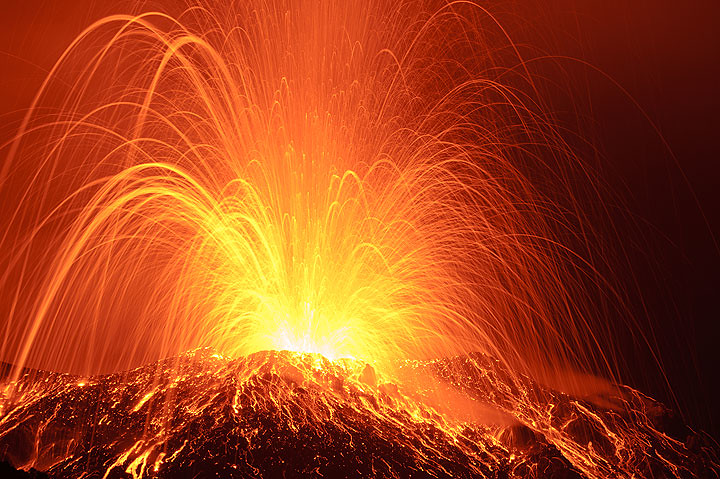
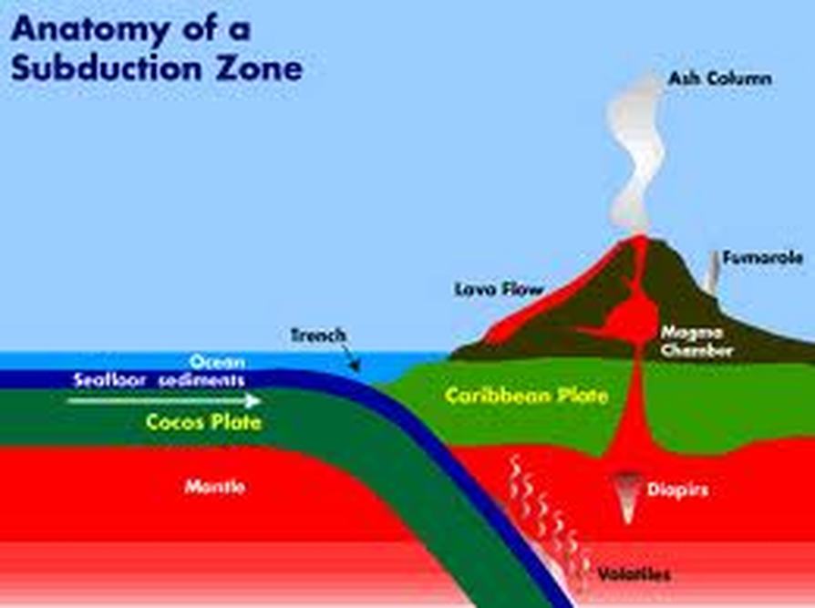
The Jordan river valley lines up with a known cause of volcanic activity.

And that is exactly what causes the Stromboli volcanic activity.
Beyond the Red Sea, which stretches for several hundred kilometers and has not a single affluent / inlet river, the aquatic life of the African lakes and rivers belongs to the so-called Ethiopian zoogeographical region / plate. [SO!] According to Annandale “the explanation of the Ethiopian [African plate affinity / presence of the fish fauna of the Jordan is that the Jordan formed at one time merely part of a river system that ran down the Great Rift Valley. The Jordan was one branch of this huge river system, the chain of lakes in East Africa represents the other; [emphasis added] and together they opened [past tense] into the Indian Ocean…” (3
Whatever the structural changes of the earth in the catastrophes before that which I describe here, there must have been some time when the Jordan streamed into the valley of Sittim (the name of the plain before the Dead Sea originated) and continued into the Mediterranean, most probably through the Jezreel Valley.
Legendary reminiscences from the patriarchal age indicate that the Jordan existed before the Dead Sea came into being.. It appears that the coming out of Paddan-aram to Canaan required the passage of a river. Today the way from Palestine to the north does not require the crossing of water. But if the Jordan did flow through the Esdraelon Valley into the Mediterranean, it had to flow in a direction opposite [northwest] to the one in which it flows today [southeast].
Does there exist any reminiscence about the Jordan changing the direction of its flow?
An inscription of Thutmose I reads: “Frontier northern [of Egypt], as far as that inverted water which goeth down in going up [emphasis added].”…The river that reversed its direction is the Jordan.
The Jordan River is not the only one to leave a trace of this earth shattering event.
The changes that this crust and tectonic movement created helped redirect the water movement in South America in different ways and eventually reversed the flow of many of the rivers in an easterly direction towards the Atlantic as opposed to the Pacific or Caribbean.