
- The included photograph was provided in answer to the question “What does Earth look like from outer space?”
-
-
The view is about 200 miles (300 km) above Earth’s surface...about the height of the orbit of the International Space Station (ISS).
OBVIOUSLY this doesn’t prove anything. Not a globular earth nor the shape of any of the continents.Let’s try the Hubble telescope.
If the Hubble Space Telescope (HST) could observe Earth from its orbit 570 kilometers (350 miles) above Earth’s surface…But it’s not possible to turn the telescope in an Earth-observing direction. Here’s why.
First, the brightness of Earth would damage the instruments aboard the telescope.
- Whaaat!!
Then what’s this? The Sun, Hubble Telescope, Solar System, Space, Stars 170568

So this “Hubble picture” is fake?! What does that tell us about NASA’s credibility?
[Hubble’s] speed in orbit above Earth is so fast that any image it took would be blurred by the motion.
Wait! Stop! What does this mean for ALL PICTURES TAKEN BY HUBBLE?
In any case, We don’t care! We just want you to prove your claim that the shape is a ball!!

What is left unsaid by NASA is that the claims that the earth rotates around itself and revolves around the sun which stands still is just a mental frame of reference placing the observer at the sun. But we know that can never happen.
And yet…
“The Copernican principle is a cornerstone of most of astronomy, it is assumed without question, and plays an important role in many…cosmological models…
What is so compelling about the heliocentric model?
“It is a very handy principle, since it implies that…we can just look very far away…at a distant part of the universe in the distant past.”
There you have it. Compliance with the Evolutionary model in denying the biblical account of a Creator.
The heliocentric model is just an idea, playing around with game pieces to try another approach to solve a puzzle.
The First Postulate of Special Relativity – think of this in terms of the rules of the game – states that it is equally scientific to think in terms of the earth standing still and the sun, moon and stars moving around the earth.
Galileo reasoned that if a ship [think earth] moved uniformly on the sea [upperspace with the sun, moon and stars], a sailor could not distinguish between the situations either the ship [earth] is in motion and the sea [upper space] is at rest or the ship [earth] is at rest and the sea [upper space] is in motion.
In Galileo’s view- the only motion that is measurable is the relative motion between the ship and the sea; hence the term “Relativity” was manifested first ever. The first step is to clarify what we mean by motion. Using Cartesian co-ordinate system in three dimensions, we can characterize any location by three co-ordinates of that space point. When we say that something is moving, what we mean is that its position relative to something else is changing. That is all motion is relative. In each case a frame of reference is part of the description of the motion.
This is why we tell our children not to stick their arms out of the car. It doesn’t matter if our own car is moving, the car we pass is moving, or both cars are moving. Our kid is going to lose that arm.
Einstein would later further develop this concept in his massive theories of General and Special Relativity in his effort to try to understand the nature of the material universe.
The “effort to understand” is called epistemology: the philosophical study of the nature, origin, and limits of human knowledge. “Along with metaphysics, logic, and ethics, it is one of the four main branches of philosophy.”
It is obvious that the nature, origin and and especially limits of human knowledge of astronomy are geocentric.

- There are hundreds, perhaps thousands of sites of archaeological importance throughout the world. Many of these sites seemed to be aligned with the flat plane precession of the equinoxes.
- .
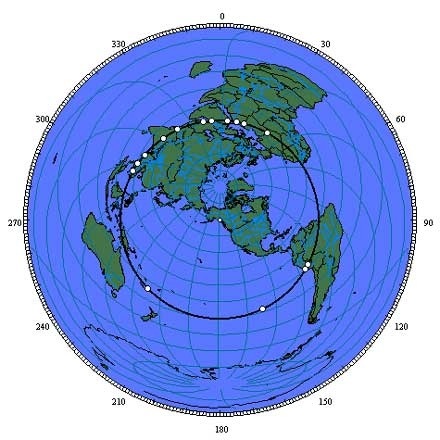 The projection is centered on the axis point in southeastern Alaska. Distances to any location from the center of an equal azimuthal projection are equally scaled.Since all of the sites on the great circle alignment are equally distant from the axis point at one quarter of the circumference of the earth, the alignment forms a perfect circle halfway between the center and the outer edge of the projection.In other words, the ancients mapped a flat plane on the surface of the earth. The accuracy with which the ancient cultures copied the flat plane precession of the heavenly bodies on the face of the earth raises a shocking question – are we being deliberately deceived as to the shape of the earth?According to an exhibit sponsored by prestigious Cornell University – Yes, we are.Latitude: Persuasive Cartography features highlights from the PJ Mode Collection of Persuasive Cartography—maps intended primarily to influence opinions and beliefs, rather than to communicate geographical information. These “persuasive” maps are focused on shaping decisions and desired outcomes. They employ a variety of tools and strategies—unusual projections and coloring, selective inclusion, imaginative illustration, allegory, satire, and even intentional deception—to advance a particular cause or point of view…
-
About the Collector
PJ Mode, Cornell Class of 1960, served in the U.S. Navy, graduated from Harvard Law School…From 1970 to 1973 he was chief counsel of the U.S. Senate Subcommittee on Constitutional Amendments and chief legislative assistant to U.S. Senator Birch Bayh of Indiana. He was a partner and later chairman of the Washington, D.C., law firm Wilmer, Cutler & Pickering…A student and collector of maps since 1980, he now focuses on collecting, researching and writing about “persuasive cartography.” The maps on view in this exhibition represent only a fraction of his collection of over a thousand maps.
National Geographic, 1924.
Gift of PJ Mode.The power of maps as a means of persuasion derives from the presumption that they are true and error-free. This advertisement from the map and atlas publisher, Rand McNally, emphasizes the point: “As a background for culture and a basis for business judgment, a set of Rand McNally Maps is of paramount importance…and invariably accurate.”
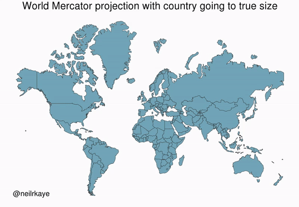
For more than 130 years Rand McNallyclassroom wall maps have indoctrinated virtually every American with the centrality and size-is-power of North America. But right there in the open, these maps portray a false view of the world. Look at Greenland. Only the darkened edges accurately reflect the landmass of this country.
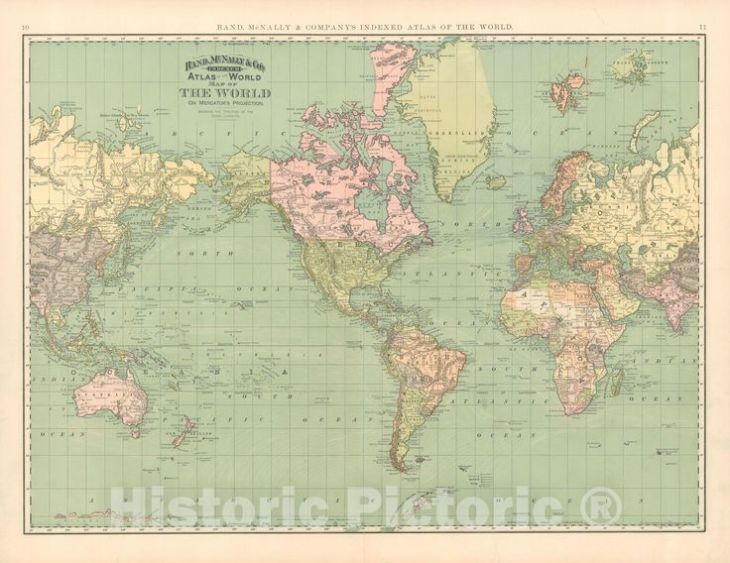
As it turns out, ALL the northern hemisphere countries are vastly over-sized.
This is recognized when the typical map is reversed north to south. Just hanging there in space as it is, there is no “right” way up after all, is there? But politically, the immediate effect is to enhance the significance of the countries south of the equator, isn’t it?

There is no question that the politically dominate Europeans – including those who settled North America – place ourselves front and center and larger than life on maps to enhance the significance of, well, European dominance over the rest of the world.
Is it possible that the Western world powers’ dominance over the rest of the world is still being portrayed through maps?
NASA – National Aeronautics and Space Administration – was established on October 1, 1958, as a part of the United States government’s space and weapons development program to maintain military superiority over, first Russia, then the rest of the world.
Landsat is a satellite system run by NASA, the first satellite was launched on July 23, 1972, with the express intent to study and monitor our planet’s landmasses. Obviously, for military purposes.
We would expect that actual images shot from above would provide the most accurate view of the worlds’ landmasses, especially for military purposes, right?
 Look at South America.
Landsat’s “image from space” matches the familiar shape we know from the old Rand McNally maps, especially the “nose” if we visualize the continent as a profile headshot.
But we now know that the Rand McNally maps are incorrect.
The 2016 winner of Japan’s prestigious Good Design…Narukawa has achieved a geographically accurate depiction of Earth.
Wow! Look at the nose on that headshot of Brazil!

Why doesn’t Landsat’s image match the AuthaGraph projection map’s shape?
It seems to me that Eisenhower’s military-industrial complex is shielding something from view of us commoners. Scoff you may, but who is the fool? The sceptic, or the blind believer?
- From War Room – U.S. Army College – Creative Thinking About National Security And DefenseMilitary strategy depends on geography to a far greater degree than what is currently practiced or taught…To the limited degree that military strategy—that is, strategy for warmaking—is delineated in contemporary theory and doctrine, the absence of attention on traditional geography is evident…Perhaps because of the last few decades of counterinsurgency-type fights, understanding the strategic environment in American military strategic theory and doctrine has become heavily focused on peoples and cultures, best evidenced by the attempts to map the so-called “human terrain…”That is a mistake…To a student of the Art of War, the study of the military geography of any country is an interesting one; but it is, perhaps, only when the study is applied to countries whose interests are closely bound to our own, whose foreign policy may clash with that of the United States, and whose territories may be the theatre of operations of our armies—or to those parts of our own land which may feel the tread of the invader—that it becomes to us a study of importance second to no branch of the Art of War (p. 6)…and indeed the literal job of the military, to prepare for such wars.And indeed the literal job of the National Aeronautics (airplanes) and Space (as in outer) Agency is to prepare for space-based wars. Including facing off against intruders from outer space.
Jonathan Grey, a current US intelligence official at the National Air and Space Intelligence Center (Nasic), confirmed…“We are not alone…”
former intelligence official David Grusch, who led analysis of unexplained anomalous phenomena (UAP) within a US Department of Defense agency, has alleged that the US has craft of non-human origin.
Information on these vehicles is being illegally withheld from Congress, Grusch told the Debrief. Grusch said when he turned over classified information about the vehicles to Congress he suffered retaliation from government officials. He left the government in April after a 14-year career in US intelligence.
-
We know that ancient cultures’ geocentric observations accurately predicted astronomical events not only for annual cycles, but for those appearing only over vast periods of time. Most telling of all are the ancient monumental structures used to accurately track the movements of the heavenly bodies.
All these observations, accepted as accurate by today’s astronomers, were, of course, made from earth, i.e. a geocentric perspective.
It is in fact, impossible, for obvious reasons other than distance, to take these measurements at the sun, to provide a heliocentric perspective. This means that anyone, from ancient to modern times, is forced to take a geocentric perspective of outer space.
Ironically, one of the most compelling reasons for a geocentric claim comes from an attempt to debunk it. In 1987 N.F. Gier stated that the “most conclusive reason for taking the Hebrew solid heaven literally is that such a view was all over the ancient world of the time.”
True that.
The sites: Giza, Siwa, Tassili n’Ajjer, Paratoari, Ollantaytambo, Machupicchu, Nazca, Easter Island, Aneityum Island, Preah Vihear, Sukhothai, Pyay, Khajuraho, Mohenjo Daro, Persepolis, Ur, Petra are shown clockwise from Giza on the equal azimuthal projection.
The Great Pyramid is aligned with Machupicchu, the Nazca lines and Easter Island along a straight line around the center of the Earth, within a margin of error of less than one tenth of one degree of latitude.Other sites of ancient construction that are also within one tenth of one degree of this line include: Perseopolis, the capital city of ancient Persia; Mohenjo Daro, the ancient capital city of the Indus Valley; and the lost city of Petra. The Ancient Sumarian city of Ur and the temples at Angkor Wat are within one degree of latitude of this line.

